Results of the 2014 European Prize for Urban Public Space
By Bustler Editors|
Wednesday, May 7, 2014
The 2014 European Prize for Urban Public Space adds a dose of reality to often romanticized European cities, showing that every city no matter where has its own set of pressing issues. The annual prize recognizes exemplary projects that have transformed and improved public spaces throughout the continent.
Starting with a total of 274 projects from 30 European countries, the international jury selected 25 finalists, and finally two joint winners and four special mentions.
Prize-winning projects are currently on exhibit at the Centre of Contemporary Culture of Barcelona (CCCB) until June 4. The projects will then travel to European and American cities.
Have a look at the winning projects below.
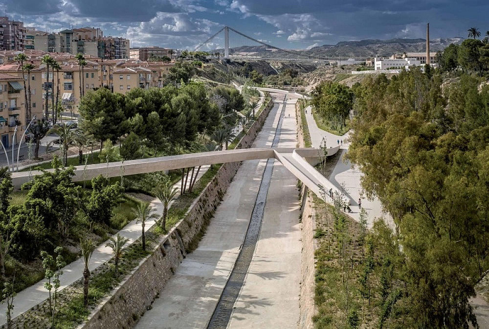
JOINT WINNER: The Braided Valley
Elx, Spain - 2013
AUTHORS: Francisco Leiva Ivorra, Marta García Chico, Prócoro del Real Baeza
DEVELOPER: Ayuntamiento de Elche
Peter Cachola Schmal comments the Joint Winner from Elche (English version, Catalan subtitles) from CCCB on Vimeo.
"The Vinalopó River is considerably reduced when it crosses the city of Elche. Irrigation upstream and very irregular rainfall mean that water only flows in any abundance in autumn, when sudden flooding can occur. This has cut out a riverbed with steep sides, mainly as a result of landslides. In the 1970s, major channelling work put an end to flooding but also eliminated the network of paths by means of which residents on the right bank could reach the adjoining Palmeral, a vast palm grove which is inscribed in the UNESCO World Heritage List. Relegated to the condition of a marginal rubbish tip, the watercourse became a barrier that divided the city into two halves, both facing away from it.
In 2009, the City Council called for entries in a competition aimed at converting the riverbed into a three-kilometre-long linear park. The first phase of the work was completed on the upstream section where the social deterioration of the neighbourhoods and scarcity of bridges made improvement most urgent. A temporary in situ office collected data on the areas of movement that were most requested by future users. A network of paths was thus opened and led the place to be known as "The Braided Valley" because they criss-cross on both sides of the river, which were also replanted with autochthonous species of vegetation. Before reaching the walls of the channel and joining to cross the riverbed, the paths rise up in a Y-shape forming two footbridges resting on clusters of metal pillars which resemble tree trunks and give lightness to the structure.
Before completing the first phase, the new city council stopped work on the project it had inherited but did not embrace as its own. “The Braided Valley” has not been officially opened yet, although local residents have spontaneously made it theirs. With similar spontaneity, the riverside paths and bridges disregard the orthogonal nature of the urban layout and anticipate tracks which a pedestrian’s common sense would leave on a badly situated parterre or on the ground of a snowbound city. It is to be hoped that common sense will prevail and that work on this park, which already stitches together the neighbourhoods through which it passes and connects them with natural spaces to the north of the city of Elche, will soon proceed anew."
PROJECT BEGINNING: 2009
START OF WORK: 2011
TOTAL COST: 2,382,000 €
SURFACE: 115,000 m2
JOINT WINNER: Renovation of the Old Port
Marseille, France - 2013
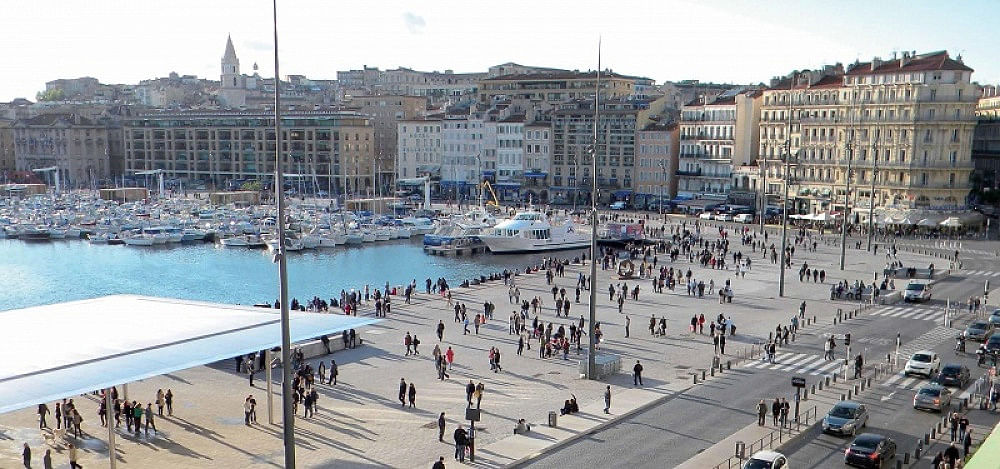
AUTHORS: Michel Desvigne Paysagiste MDP, Foster + Partners, TANGRAM, INGEROP, AIK AIK
DEVELOPER: MPM Communauté urbaine Marseille Provence Métropole, Direction des Infrastructures
Matevž Čelik comments the Joint Winner from Marseille (English version, Catalan subtitles) from CCCB on Vimeo.
"The Vieux-Port of Marseille is the largest urban harbour in Europe. The foundational site of the capital of Provence, it was also the region’s economic centre until midway through the nineteenth century, when transport of goods and passengers was moved to the Grand Port Maritime. The old harbour has a narrow entrance flanked by two old fortifications and it occupies a natural bay where the central districts of the city converge. However, despite its beauty and central location, the port fell into neglect and a state of disrepair by the end of the twentieth century. The premises of yacht clubs, which cluttered the port with architectural and visual barriers, blocked public access to 80% of the docks area where, moreover, the fact that priority was given to cars, discouraged pedestrian use.
In 2009, the City Council and the Marseille Provence Métropole (MPM) called for entries in a competition aimed at rectifying the situation. The first phase of the renovation work has cleared obstacles and vehicular transport from the port’s three wharves, which are now uniformly paved in pale granite evoking the original limestone cobblestones. The Quai des Belges, the central wharf, devotes 60% of its surface to pedestrians and protects them from the sun beneath the Grande Ombrière, a rectangular canopy of 1,000 m2, which can also be used for large crowd-pulling events. New floating docks have been installed in order to accommodate water activities without interfering with the pedestrian flow or views.
Thanks to a consultative process, which took into account the suggestions of residents, businesspeople and local associations before calling for entries in the competition, the port has recovered its vitality by means of taking the general interest into account. The presence of leisure craft, which fosters economic and associative activity, has been made compatible with access and enjoyment for all citizens. Hence, while other city ports combat economic decline by allowing privatised uses that undermine their role as public space, the Vieux-Port has been renovated by expanding its condition of a shared place that is open to everyone."
PROJECT BEGINNING: 2011
START OF WORK: 2012
TOTAL COST: 45,000,000 €
SURFACE: 12,000 m2
SPECIAL MENTIONS
SPECIAL MENTION: Opening of Rainham Marshes
London, United Kingdom - 2014
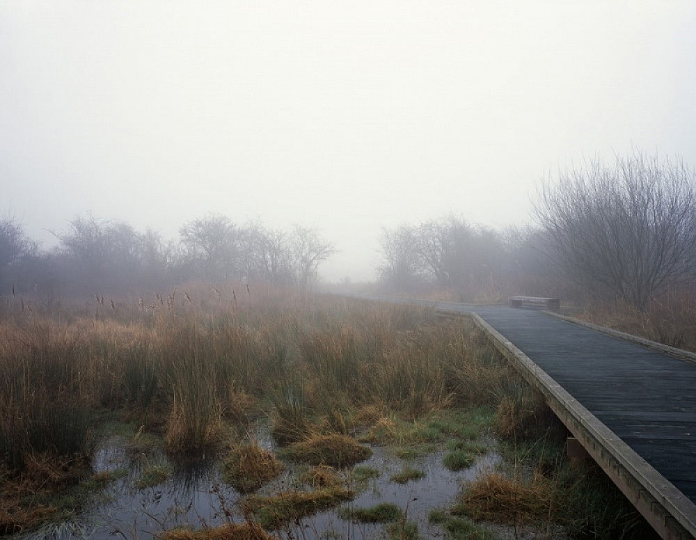
AUTHORS: Peter Beard_LANDROOM | Peter Beard, Alexander Gore, Sabba Khan, Dingle Price, Gregory Ross, Mark Smith, Keita Tajima
DEVELOPER: Greater London Authority | London Development Agency | Design for London | London Borough of Havering | Royal Society for the Protection of Birds
Juulia Kauste comments the Special Mention from London (English version, Catalan subtitles) from CCCB on Vimeo.
"Rainham Marshes, on the eastern edge of London constitute the largest floodplain to the north of the Thames estuary. They take in the towns of Purfleet and Thurrock, as well as Rainham suburb, which belongs to the London Borough of Havering. Despite their proximity to Europe’s largest metropolitan area, the marshes still conserve many of the traditional features that characterised them in the Middle Ages, when they were used for grazing sheep and cattle. Since they are also home of a great diversity of migratory birds and rare plants, they have been given the highest level of habitat protection designation in the United Kingdom. If this zone survived the typical environmental devastation caused by industries and infrastructure on city outskirts, it is because it was a firing range belonging to the British Army until 2000, when it was acquired by the Royal Society for the Protection of Birds (RSPB) and the London Borough of Havering.
In 2006, as the marshes were opened to the public, a series of interventions was underway with the aim of improving accessibility. In the centre, earth was moved to fill an old rubbish tip and create a silt lagoon, while the wetlands remain at both sides. The western ones, crossed by six footbridges in weathering steel and connected with Rainham suburb by the Trackway Bridge, are once again used for grazing. At the eastern ones, near Purfleet, the landscape is mainly doted by reed-beds and overseen by an RSPB bird-watching lookout. Several sculptural elements in Portland stone have been placed in different parts of the marshes, to be used as benches or to evoke the military past of the zone.
Since they were opened up, these wetlands have found a new place in the public imagination of Londoners, who can now enjoy wild nature near the city. Some criticism has been voiced about the introduction of excessively anthropic elements which may distort the real experience of a truly wild landscape. It has also been noted that high levels of public access may irreversibly interfere with the delicate environmental balance of the place. However, accessibility is the necessary condition for people discovering, learning to love and defending these marshlands which, otherwise, would not last long."
PROJECT BEGINNING: 2003
START OF WORK: 2006
TOTAL COST: 6,000,000 €
SURFACE: 6,400,000 m2
SPECIAL MENTION: Islamic Cemetery
Altach, Austria - 2012
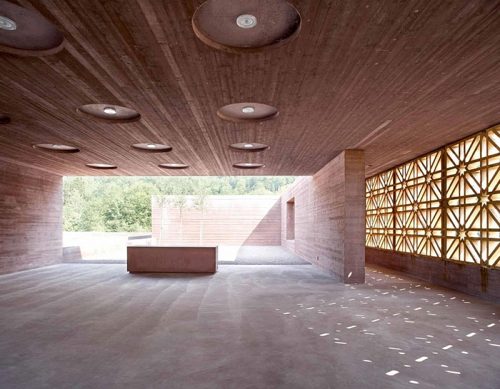
AUTHORS: Bernardo Bader Architects
DEVELOPER: City Council of Altach
Sarah Ichioka comments the Special Mention from Altach (English version, Catalan subtitles) from CCCB on Vimeo.
"The town of Altach is in the federal state of Vorarlberg where, although 78% of the population is registered as Catholic, Austria’s largest concentration of Muslims resides. In recent decades, immigration has multiplied the number of practising Muslims living in the country, which has been significant in Western Europe since 1979 when the Islamic community was acknowledged as a corporation under public law, and the religious freedom of Turkish, Bosnian, Afghan, Kurdish, Chechen, Iranian, Arab or Pakistani Muslims was thus recognised. Nevertheless, Austria only had one Islamic cemetery until 2012. Moreover, such religious requirements as bathing the deceased, burial without a coffin, and collective prayer in the Musallah (prayer hall) require highly specific installations, but the town of Altach was willing to satisfy this need.
In 2004, several communities of Muslim immigrants organised a joint initiative to request a cemetery where they could bury their dead in the land where they have settled. Nine years later, and with support from the local council, the cemetery was opened. It is organised around six spaces with parallel walls which, owing to the road running past the cemetery, are staggered in their layout so that they are all oriented towards Mecca. Five of these spaces are unroofed burial enclosures, while the sixth contains facilities for ablution rites, congregation and prayer. The main entrance façade, which closes off the courtyard and the Musallah, features oak latticework, thus combining the local woodcraft tradition with the abstract geometry of Islamic art.
If the European nature of the cemetery is not evident, neither is its quality as urban public space. Questioning its public condition from the standpoint of secularist requirements would be unjust given the profusion of bell towers in Europe’s squares. The urban-space aspect of the place can be defended on the basis of its capacity of satisfying the demand of a very significant minority in the region. Most difficult of all is to exclude it from the idea of Europe. This is not only because, since its very beginnings, Islam has been clearly present in the history of the continent but also – and especially – because increasing numbers of Europeans of different origins are contributing towards making plurality one of Europe’s greatest riches."
PROJECT BEGINNING: 2007
START OF WORK: 2009
TOTAL COST: 2,300,000 €
SURFACE: 8,400 m2
SPECIAL MENTION: Baana: pedestrian and bicycle corridor
Helsinki, Finland 2012
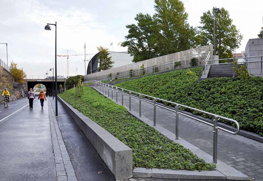
AUTHORS: Helsinki City Planning Department, Helsinki Public Works Department, Loci Landscape Architects Ltd
DEVELOPER: Helsinki City Executive Office
Katharina Ritter comments the Special Mention from Helsinki (English version, Catalan subtitles) from CCCB on Vimeo.
"In 1894 a railway line was constructed on the edge of the Helsinki city centre, running between the central station and Länsisatama (“West Harbour” in Finnish). This required the excavation of an open-air canyon of seven metres deep and almost a kilometre and a half long. Helsinki subsequently expanded, surrounding the cutting which, although crossed by seven bridges, still constituted a gash in the urban fabric. In 2008, the cargo port was moved to the Vuosaari neighbourhood and work began on a new residential zone in Länsisatama. The railway connection was no longer necessary and questions about the future of the cutting were being asked.
Covering the canyon to make an underground tunnel would restore continuity to the urban layout, but this option is expensive and will take time. Meanwhile, in a process that has involved residents, university students and a range of municipal departments, the space has been temporarily converted into a corridor for pedestrians and cyclists. Linking Länsisatama with the city centre by way of a series of landscaped areas pervaded with railway motifs, the track has been named “Baana”, or “Rail” in colloquial Finnish. Bike lanes have been asphalted and access has been provided from both sides, although the original tracks and stone walls have been conserved. The rugged darkness of the cutting contrasts with nearby sports and artistic installations in colours as bright as those of the goods containers that used to move along the track.
Austere, versatile and resistant, this recycling of the railway track has been embraced by very different kinds of users. It is so successful that widened bike lanes are now being considered, and even the possibility of extending a “Baana network” of similar tracks throughout the city. Fruit of a complex process of cooperative endeavour involving the administration, academics and residents, this example of temporary urban planning safeguards industrial memory, saves resources for the future, and also establishes a non-commercial shared space. With this successful balancing of costs and benefits it would seem that the eventual project of covering of the cutting can wait."
PROJECT BEGINNING: 2003
START OF WORK: 2009
TOTAL COST: 5,000,000 €
SURFACE: 16,000 m2
SPECIAL MENTION: La Lira Theatre
Ripoll, Spain - 2012
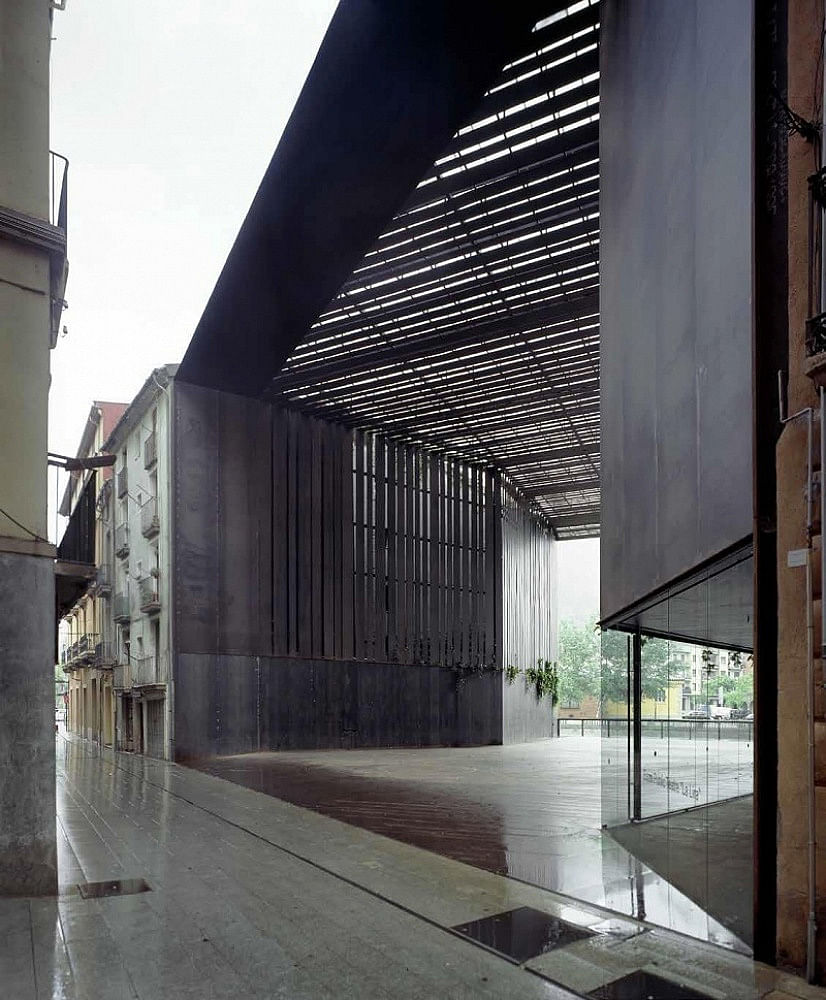
AUTHORS: RCR Aranda Pigem Vilalta Arquitectes SLP, Joan Puigcorbé
DEVELOPER: Ajuntament de Ripoll
Francis Rambert comments the Special Mention from Ripoll (English version, Catalan subtitles) from CCCB on Vimeo.
"For many years after the demolition of the “La Lira” theatre, a vacant lot remained in the centre of Ripoll, a town of high annual rainfall in the Pyrenees foothills. With blind flank walls on either side, the empty block afforded some breathing space in the narrow Verdaguer street but it also broke the continuity of the urban façade overlooking the River Ter. This gash was highly visible to many outside visitors who entered the town from the railway station or by road to visit its Romanesque Monastery. It was also an unsightly interruption in the town’s connection with the river which, from the Middle Ages until well into the twentieth century, supplied water for Ripoll’s metallurgical industry, which was renowned throughout Europe because of its use of the “Catalan forge”.
In 2003, the local council called for entries in a competition with a view to converting the vacant lot into a public space. The land is now occupied by a new theatre which, benefitting from the demolition of the original one, has kept the same name. Today’s “La Lira” theatre takes the form of a high porch sheltering a versatile open space, beneath which there is an underground multi-use room. Although the ceiling is impermeable, it lets light through by means of parallel slats which fold down on either side to cover the flank walls. The intervention as a whole has thus become a window that reconstitutes the riverfront facade and frames the view of the mountains from Verdaguer street. It is also a gateway giving access to the old town centre by way of a footbridge crossing the River Ter.
Both porch and bridge are made of weathering steel. The rough surface of the meta fits well with the aged facades of the adjacent buildings, while the diversity of its treatments evokes the metallurgical tradition of the town. However, the most pertinent tradition recovered by the new “La Lira” is that of nineteenth-century markets and railway stations which have managed to remain somewhere between the closed building and the open space. Like those public porches, the new theatre in Ripoll avoids wasteful use of glass and air-conditioning, while gaining in versatility in the ways in which the space can be used, as well as showing solidarity with its urban setting."
PROJECT BEGINNING: 2004
START OF WORK: 2005
TOTAL COST: 761,219 €
SURFACE: 599 m2
Photos courtesy of the 2014 European Prize for Urban Public Space

Share
0 Comments
Comment as :