Results of the Dallas Connected City Design Challenge
By Bustler Editors|
Monday, Mar 10, 2014
Related
A city that is connected -- in all senses of the word -- is a good city. The finalists of the Dallas Connected City Design Challenge offered numerous solutions in how Downtown Dallas can be linked to the Trinity River.
To guarantee a variety of ideas for Dallas' future development, the competition invited submissions in a Professional Stream and an Open Stream. Three Professional and 4 Open entries won.
Professional (selected by jury):
- Stoss + SHoP, Boston, MA: "HyperDensity/HyperLandscape"
- Ricardo Bofill Taller de Arquitectura, Barcelona, Spain: Dallas: "Downtown & Trinity"
- OMA*AMO, New York, NY: "2Rivers/2Datums"
Open (selected by jury and public voting):
- Kohki Hiranuma of Kohki Hiranuma Architect & Associates, Osaka, Japan: "Forest"
- Bogdan Chipara of Constanta, Romania: "Bridging"
- Raik Thonig and Marius Kreft of University of Texas at Arlington, Arlington, Texas
- McLain Clutter of University of Michigan, Ann Arbor, Michigan
Professional finalists received US$50,000 each to bring their ideas to the Dallas Challenge. Open finalists earned US$5,000 each and will partake in public exhibitions and events.
Learn more about the winners below.
Professional finalist: Stoss + SHoP, Boston, MA: "HyperDensity/HyperLandscape"
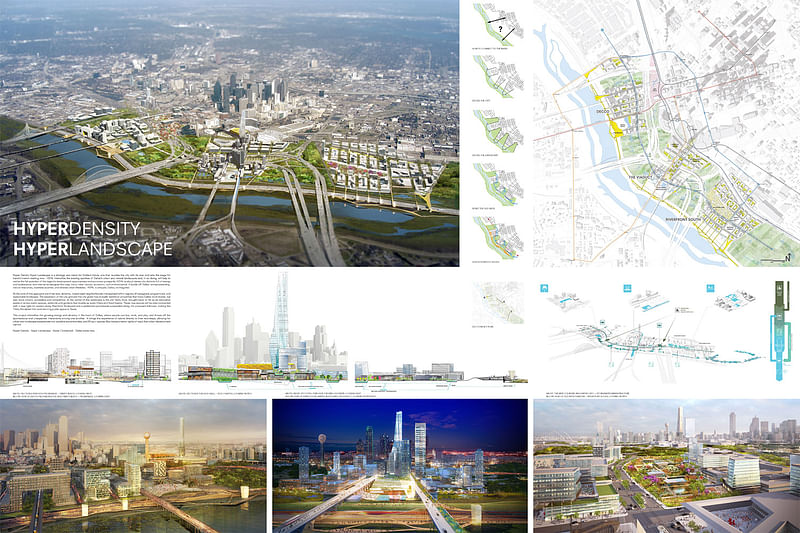
"Hyper Density Hyper Landscape is a strategy and vision for Dallas’s future, one that reunites the city with its river and sets the stage for transformation starting now. HDHL intensifies the existing qualities of Dallas’s urban and natural landscapes and, in so doing, will help to realize the full potential of the region’s development opportunities and economic prosperity. HDHL is about dense city districts full of energy and exuberance, and intense landscapes that play many roles—social, economic, and environmental. It builds off Dallas’ entrepreneurship, natural resources, business acumen, and diverse urban lifestyles. HDHL is uniquely Dallas, re-imagined.
At the core of this approach are three new, dynamic, mixed-used neighborhoods interspersed within regions of variegated, programmed, and sustainable landscape. The expansion of the city grid and the city green has mutually beneficial properties that make Dallas more livable, but also more vibrant, accessible and competitive. At the center of this landscape is the old Trinity River, brought back to life as an innovative series of active public spaces, wetlands and gardens that double as water filters and flood basins. These new spaces will be inter-connected with a new light-rail system along Riverfront Boulevard and a pedestrian promenade suspended along the proposed toll-road, making the Trinity floodplain the most exciting public space in Texas..."
For the full narrative, click here.
Professional finalist: Ricardo Bofill Taller de Arquitectura, Barcelona, Spain: "Dallas: Downtown & Trinity"
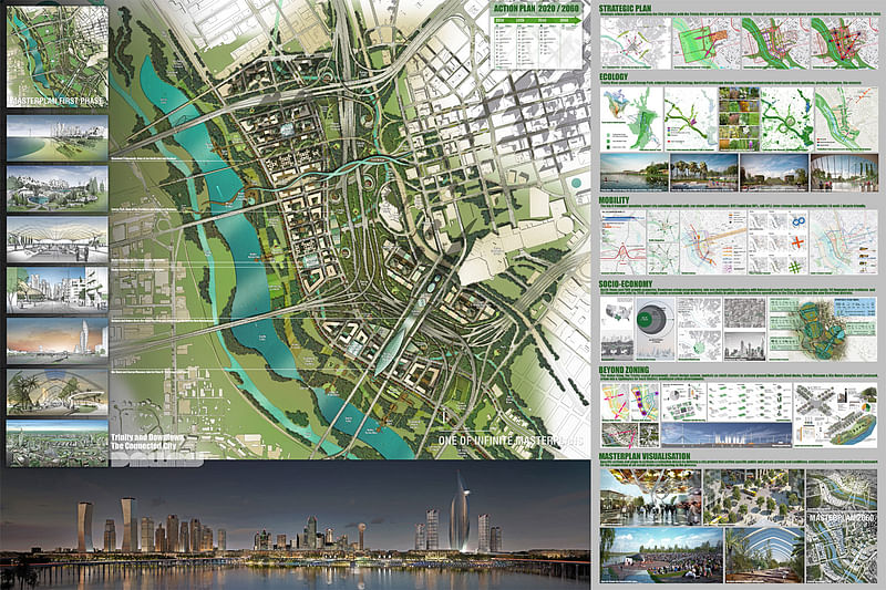
"The strategic plan aspires to be part of a collective dream, from the past Native American history to contemporary culture. The project’s vision ensures that Downtown Dallas grows with a comprehensive integration of ecology, transportation, land-use and socio- economy. The urban sequence extends from the Arts District, lengthening the pedestrian corridor to the new Science & Nature Program and Energy Park, and Leisure Trinity Park and new Sunset Promenade.
'D walk' is a concept that connects the DMA to the Perot Museum, across to the JFK Memorial, and across through the new bridges, connecting Main Street with the River, the Bio Dome, parks and new lakes. The original Blackland prairie environment becomes ecological support that provides an intense street level hard/soft landscape design, with planting along all main streets, and a network of magnets: the +E Museum & Park (with pavilions) and outdoor neighborhood markets, that regenerate nature through local/global bio-mimesis.
District by district design and inter-urban connections, create a sense of place and identity, a “genius-loci” from where to grow. The Trinity Riverfront promenade becomes the urban/ natural spine with magnets to activate a living ground floor where interior and exterior streets are connected, leading to multi-level decks overlooking the Trinity Lakes and Parks..."
For the full narrative, click here.
Professional finalist: OMA*AMO, New York, NY: "2Rivers/2Datums"
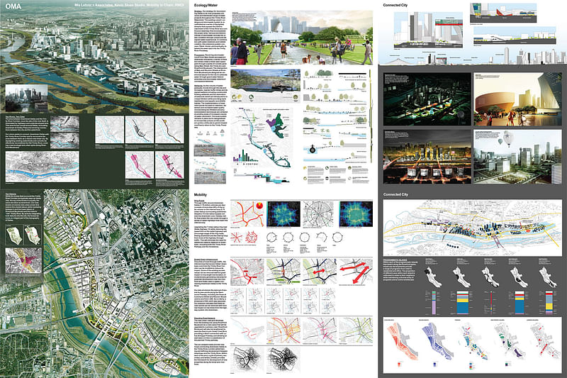
"The area between Dallas and the Trinity River Corridor is currently dominated by highways and underdeveloped land. This zone forms a moat around Dallas, truncating downtown at Dealey Plaza and severing the city from the waterfront. Our vision seeks to connect downtown Dallas and the Trinity River Corridor and to reconceive the zone between them as a vibrant new linear city. Daylighting and filtering existing watersheds and culverts reconstitutes the Old Trinity River to create a new ecological spine along Riverfront Boulevard.
This new ecology provides a foundation for development by increasing property values and establishing a new, legible amenity zone adjacent to downtown. To connect across I-35 and the railway, four strategic interventions stretch over and under them. At the North and South, new pedestrian bridges provide access to key DART stations. Closer to Downtown, Dealey Plaza and the viaducts at Houston and Jefferson are transformed to provide new gateways into the site..."
For the full narrative, click here.
Open finalist: Kohki Hiranuma of Kohki Hiranuma Architect & Associates, Osaka, Japan: "Forest"
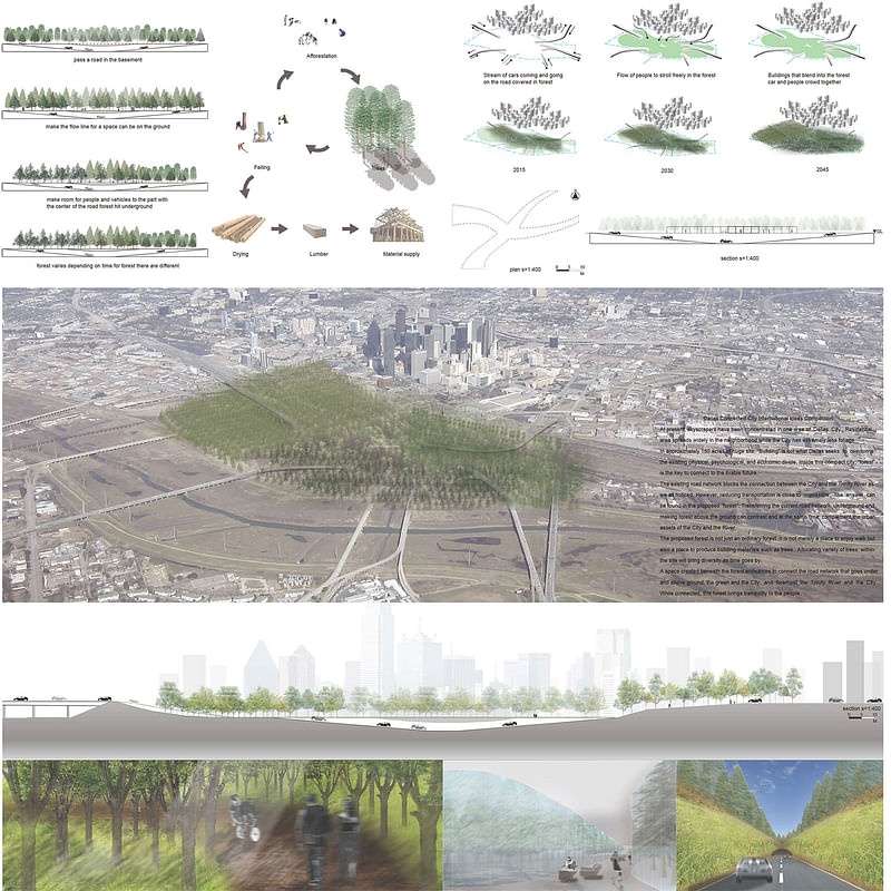
"At present, skyscrapers have been concentrated in one area of Dallas City. Residential area spreads widely in the neighborhood while the City has extremely less foliage. In approximately 150 acres of huge site, “Building” is not what Dallas seeks to overcome the existing physical, psychological, and economic divide. Inside this compact city, “forest” is the key to connect to the livable future.
The existing road network blocks the connection between the City and the Trinity River as we all noticed. However, reducing transportation is close to impossible. The answer can be found in the proposed “forest”. Transferring the current road network underground and making forest above the ground can contrast and at the same time, complement the urban assets of the City and the River. The proposed forest is not just an ordinary forest. It is not merely a place to enjoy walk but also a place to produce building materials such as trees. Allocating variety of trees within the site will bring diversity as time goes by.
A space created beneath the forest endeavors to connect the road network that goes under and above ground, the green and the City, and foremost the Trinity River and the City. While connected, this forest brings tranquility to the people."
Open finalist: Bogdan Chipara of Constanta, Romania: Bridging
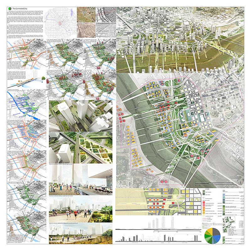
"The intention of connecting the city to the river can be seen in drawings from the early 19th century. George Kessler followed this intention in his city plans which envision Dallas expanded until the edge of the riverbed. The current proposal follows this intention, and adds a new one by which the habitat of the river is expanded towards the city. Thus, the site, situated in between those two environments, is influenced by them in equal measure. The areas themselves are divided in two: one half is occupied by plots for constructions and roads, and the other half is covered with vegetation and pedestrian walkways.(see pie chart)
The proposed elevated walkways create a flow of circulation from the city into the riverbed by passing over the freeway/railway infrastructure and also over the levee. They create a secondary pedestrian circulation layer by connecting the lower levels of the proposed buildings and descend on the ground level of the riverbed. Their second role is to sustain an irrigation system which brings water from Trinity River into the site. This water is used once, to sustain eight parks, and second, to transform the areas adjacent to the freeway infrastructure (inaccessible and not suitable for building) into one large green area.
The site and the riverbed areas form a connection between the Eastern and Western parts of the city. The additional volumes designed outside the site area are meant to suggest this urban connection."
Open finalist: Raik Thonig and Marius Kreft of University of Texas at Arlington, Arlington, Texas: "Baroque Forest"
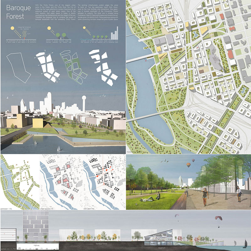
"With the Trinity Forest and River the City of Dallas has the huge potential to connect Downtown to an extensive system of open green space. This proposal tries to unlock these potentials by creating an urban fabric that is defined by public space, providing the frame for developing vibrant urban neighborhoods. The size of the project site allows the coexistence of urban density and extensive green space.
Main reasons that public space in dallas is mostly unutilized are high temperatures and the impact of the sun. Therefore this proposal tries to combine the assets of baroque boulevards with the spreading Trinity Forest, using shade as a vital element of public space. Routing the highway underground for a certain distance makes blending with the existing grid possible and allows creating pedestrian access from downtown to the new Trinity River Waterfront with its extensive recreational spaces.
The still existing highways edge the areas to build on. Furthermore two big greenways are supposed to reach from Downtown to the river forming vital connections. These greenways along with some connecting corridors shape the grid of public space. Public buildings are located at junction points of the public space.
An iconic new building is located at a vital entrance point to Downtown, next to the bridge of Commerce Street leading to Main Street. The railroad tracks are routed underground for a certain distance. At the junction of different lines, a new train station is proposed. It is located at Dealey Plaza at the endpoint of Main Street."
Open finalist: McLain Clutter of University of Michigan, Ann Arbor, Michigan: "Incentive Network"
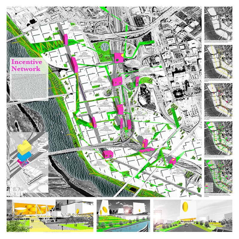
"Incentive Network aspires to channel private investment to sites that are critical in providing access for pedestrians and bikes across the wide bands of infrastructure currently severing downtown Dallas from the waterfront. The scheme begins by identifying areas where the divisive highways and railways rest on the ground. These zones comprise the best opportunities to bridge across the infrastructure. Areas within these zones are then parceled for development, at allowable floor area ratios (FAR’s) radically in excess of those stipulated by the zoning currently governing the waterfront. In exchange for building to these increased FAR’s, developers must provide public access and amenity at the elevated bridge level.
Thus, this scheme incentivizes the development of a constellation of towers providing bridges across the highways and railways. These public platforms then connect to a bike and pedestrian network that utilizes otherwise worthless space under highways and overpasses. Between this network, all developable land that is currently underdeveloped or empty is identified and parceled within an extension of the downtown Dallas city grid to be developed over time, and a new major surface road is introduced – east of the waterfront, in order to maintain public access to the river.
A new light rail loop is also introduced, looping through the site with stops at several of the new towers. Thus, the constellation of towers becomes a collection of localized sub-centers. They are iconic elements that define the space between though their dialogue with one-another, while providing public amenity and infrastructural connections."
Images via Dallas Connected City Design Challenge.

Share
0 Comments
Comment as :