University of Maryland wins ULI Hines competition a second time for 2015
By Bustler Editors|
Friday, Apr 10, 2015
For the second year in a row, the University of Maryland won the Urban Land Institute Hines 2015 competition! Founded by Gerald D. Hines, the competition challenges multidisciplinary graduate student teams to propose a comprehensive redevelopment program for a designated U.S. metro area. While the competition presents hypothetical situations, this year's competition simulates an actual urban design+development scenario in parts of the Tulane/Gravier and Iberville neighborhoods in downtown New Orleans.
Round One began with 120 teams of 600 graduate students from 60 North American universities, down to four finalists. Finally, the University of Maryland team won the US$50,000 prize with their entry "The Crossing", and the three finalist teams received $10,000 each. According to the organizers, the competition is a design exercise with no intention that the students' plans will be implemented as part of any revitalization of the site.
Check out the winning entry below.
Project description:
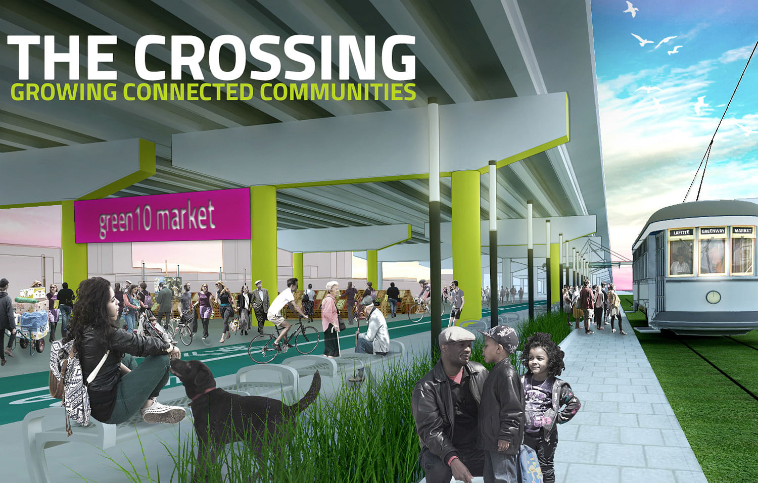
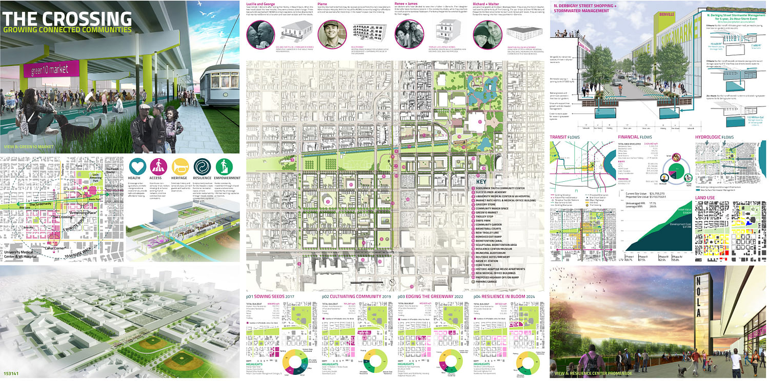
"The Crossing development sows the seeds of resilience across the Bienville, Iberville, and Lafitte neighborhoods. By connecting tourist and native, greenway and park, neighborhood and city, The Crossing functions not only as a marketplace of goods, but of ideas and relationships. This commingling of people and place fosters diversity, neighborhood cohesion, and economic opportunity. Development around The Crossing is rooted in the current social and spatial fabric of adjacent neighborhoods. The NCNIA Community Development Corporation cultivates opportunity by ensuring that 20% of all developed residential and retail units remain afford - able for current residents and business owners. The typologies of the new retail street transition in scale, offering visibility from I-10 in a fashion that blends seamlessly with Bienville’s existing shotgun homes. Profits generated by the development are reinvested in community projects, such as the demolition of the I-10 exit 235A or the multifamily makeover of Steel and Aluminum Factory. These programs assure local residents that investing in growth can, in fact, anchor a neighborhood’s character."
"The project reclaims the whole southbound segment of Clairborne Avenue adjacent to the I-10 underpass. The lanes between Lafitte Avenue and Canal Street are repurposed with natural turf and bioswales, allowing pedestrians safe access to programmed recreational space underneath I-10. This green space also hosts a portion of the proposed Iberville/Treme streetcar line, which ter - minates at the northern edge of the French Quarter. Southbound vehicular traffic is diverted across the neutral ground to the for - mer northbound side of Clairborne Avenue, which momentarily serves as a bidirectional two-lane street. Alternatively, drivers may choose to funnel through the new retail street. The added traffic will reduce traveling speeds, ensuring commercial relevance and optimal conditions for pedestrians."
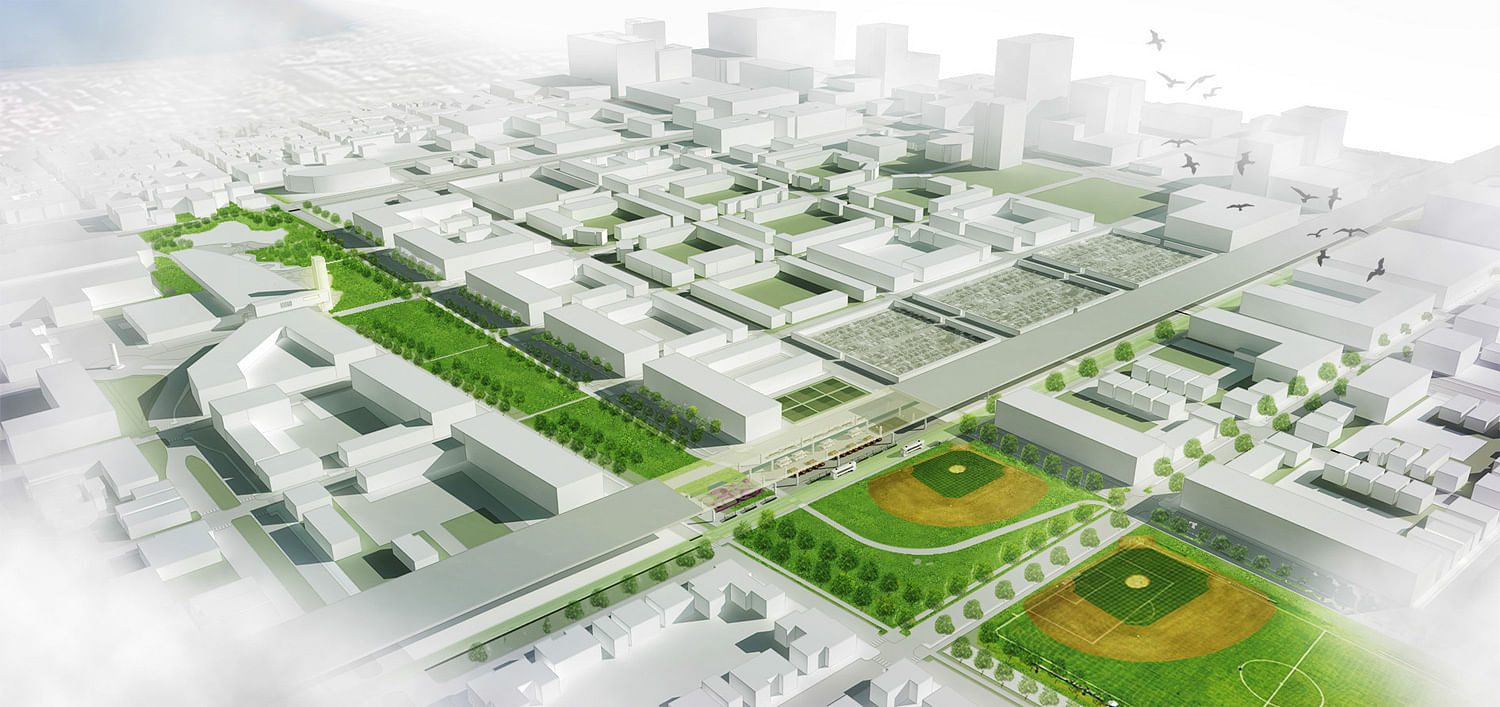
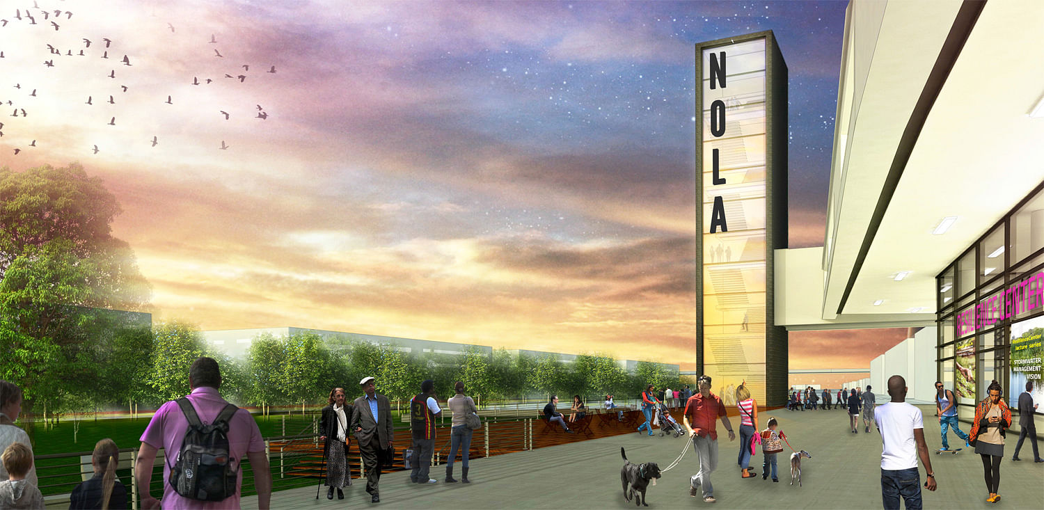
"Beyond connecting people, The Crossing serves as the intersection between Louis Armstrong Park and the Lafitte Greenway, which have grown together to become one contiguous space. The Greenway’s trail channels pedestrians and cyclists from points as far west as City Park. The pedestrian trail and cycle track continue through the park to the western edge of the French Quarter, but not before traversing the Resilience Center’s Basin. Resilience Basin symbolizes the city’s delicate relationship with water. Filled in 1938, the historic basin once served as the turning point for boats traveling along the Carondelet Canal. The restored basin now functions as a bioretention area and public space. The deck over the basin now alludes to the city’s endurance despite devastating acts of nature.
The Center’s tower functions as an architectural focal point, which sparks interest from park users. Inside the Resilience Center, visitors learn about urban agriculture techniques and weatherization strategies. Locals impacted by Hurricane Katrina share flood narratives and provide authentic entertainment services, such as washtub bass lessons, to tourists who want to taste the real flavor of New Orleans. As Bienville, Iberville, and Lafitte absorb residential demand, The Crossing development plan pulls these diverse communities and tourists toward a central point of interaction. Implementation will allow the communities to reap the harvest of connected growth."
FINANCING STRATEGY
"The North Clairborne Neighborhood Improvement Association (NCNIA) will develop “The Crossing” in a joint venture partnership with an experienced developer and a private equity investor. Across a total area of 2.4 million square feet, the NCNIA Community Development Corporation will create 1,532 residential units, 275,000 SF of retail and office, two hotels with 423 rooms, and 2,136 parking spaces. Twenty percent of all residential, office and retail units will be affordable for low-income business owners and households at 60% AMI. With total development costs of $372,781,402 million spread across four phases, the site asset value will increase from $24.7 million to $519.6 million by 2026.
Development costs include the purchase of blocks H-K for $24.3 million, as well as new commercial infrastructure and an I-10 rehabilitation fund to clean and prepare programmed space beneath the highway. Loans, subsidies and equity contributions will finance the costs. Construction loans are rolled over to permanent loans after each phase. The increasing interest rates for construction loans are estimated at 200 basis points over prime (5.25 %), while permanent loans can be obtained at 200 basis points over 10 year treasury bonds (3.90 %). These loans, at an average Loan-To-Value (LTV) of 64.0%, are secured with subsidies and equity. Over the ten year phasing period, subsidies include $3.5 million of Low-Income Housing Tax Credits, $1.7 million of State and Federal Historic Preservation Tax Credits, as well as $10.7 million of HOME grants for the construction of affordable rental units.
Equity will be accumulated in the Joint Venture. NCNIA CDC and the developer will respectively contribute $3.3 and $4.9 million worth of land. This will allow a respective 9.9% and 15% share in the joint venture. The developer’s expertise and track record will facilitate access to financing, while NCNIA can assure subsidies and community support. Finally, the private equity investor will provide $25 million in capital to receive a 75.1 % equity share. After disposition in year 10, the shareholders will realize an unleveraged Internal Rate of Return (IRR) of 17.1% and a leveraged IRR of 28.6 %. Their shares thereby appreciate to $20 million, $31 million, and $155 million respectively. As a non-profit Community Development Company, NCNIA will reinvest its profits in the construction of the Resilience Center. It will also seek out other partnerships to foster sustainable, equitable growth within the community.
Projected increases in land value position The Crossing as a prime candidate for a tax-increment financing district. New Orleans may implement this strategy as a means of financing large public infrastructure projects proposed in the plan, such as the streetcar lines on Clairborne and Rampart Streets, and the I-10 exit ramp (replacing the demolished ramp between blocks K and J) due south of Canal Street. In sum, the project’s proposed financial structure benefits both private interests and the general public in a manner that is sensitive to the current community’s character."

Share
0 Comments
Comment as :